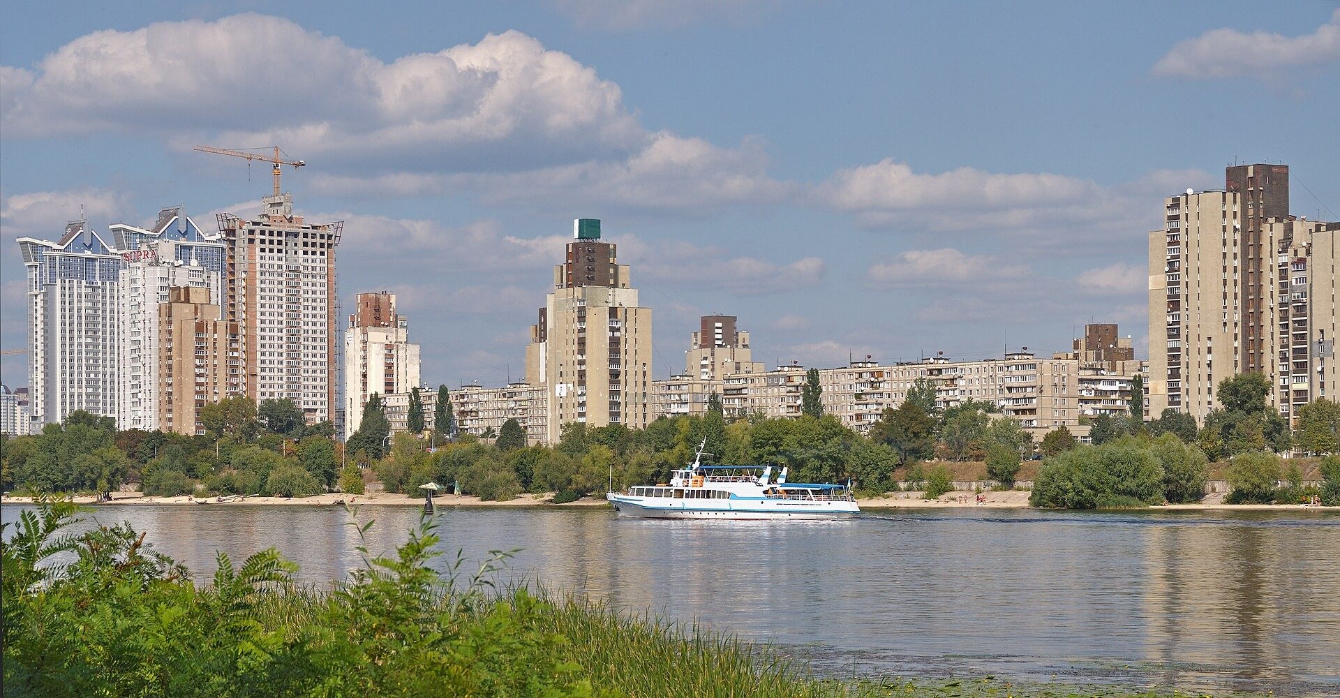
The Obolon corridor deep dive begins with the long, curved strip of land where Kyiv meets the Dnipro River north of the city center. This stretch runs from the Hydropark bridges up past the residential towers of Obolon District and on toward the northern floodplain edges. War damage, flood risk, and years of deferred maintenance left piers, embankments, and housing facades in uneven condition. Recovery here means more than new paint; it means rebuilding public access, securing the bank against water, and restoring value for residents who never left as well as those who plan to return.
The Physical Outline of the Riverfront Strip
Obolon’s waterfront is not a single park. It is a sequence of concrete embankments, sandy inlets, marina slips, and apartment blocks set twenty to eighty meters from the water. Key landmarks include the Obolon Island area, the former yacht club zone, and the long promenade that once linked residential courtyards to the river. Bridges and metro lines cut across at intervals, so the corridor functions as both a neighborhood edge and a transit seam. Walking the length today reveals patched railings, missing lighting poles, and sections where the bank has eroded after high water seasons.
Precise boundaries matter for any recovery plan. The southern end ties into denser central districts; the northern end opens toward less built flood meadows. Planners treat these segments differently because soil, ownership, and flood height vary. Residents who live in the towers know the difference between a solid embankment walk and a muddy track that appears after rain. That lived knowledge is now feeding the technical maps used for reconstruction.
War Scars Visible on Embankments and Piers
Direct hits and secondary shocks cracked retaining walls and shifted foundation piles under older walkways. Some piers lost decking or lighting infrastructure. Debris from damaged buildings farther inland washed into storm drains that empty into the river, clogging outlets and raising local flood risk. Early post-conflict surveys catalogued these points so that repair crews could prioritize structural safety over cosmetic work.
Not every scar is dramatic. Corrosion accelerated where protective coatings failed and moisture stayed trapped. Handrails that looked intact proved loose when load-tested. These quieter failures still close sections of path and keep families away from the water. The first recovery contracts therefore focused on load-bearing elements and drainage rather than benches or cafes.
Engineering the Bank Against Flood and Erosion
Ukrainian engineers combine traditional piled embankments with newer soft edges that allow water to rise without destroying hard surfaces. Sheet piles, reinforced concrete walls, and rock armor appear where the bank is steep. Where slopes are gentler, planted bio-engineering solutions slow water and trap sediment. Both approaches must meet updated flood models that account for climate trends as well as wartime changes in river management.
Drainage is the hidden half of the work. Storm sewers that once emptied freely now require sediment traps and backflow valves. Without them, heavy rain pushes water back into basements of nearby buildings. The Ukraine recovery portal lists coordinated riverbank packages that combine these civil works with public-space upgrades so that money is not spent twice on the same stretch of bank.
Housing Stock Facing the Water
Thousands of apartments look directly onto the corridor. Many towers date from the late Soviet and early independence periods; others are newer mid-rise complexes. Facade damage ranges from cracked panels to missing windows and compromised balconies. Interior systems (heating risers, elevators, electrical risers) often need parallel repair so that people can reoccupy units safely.
Ownership patterns shape the pace of work. Cooperatives and condominium associations must approve and co-fund some improvements. Units owned by people still abroad create decision delays. At the same time, returning families and new buyers look for river views that feel secure. Readers following the Kyiv Real Estate Market Outlook for 2026 already note that Obolon listings with restored waterfront access command attention once structural certificates are in place.
Paths, Lighting, and Everyday Access
A recovered corridor must let people walk, cycle, and sit without detours. Continuous lighting, clear sight lines, and barrier-free ramps turn the bank into usable public space rather than a residual strip. Existing tree lines are being inventoried so that mature canopies stay while damaged specimens are replaced. Small plazas at bridge landings can host markets or simply give residents a place to meet after work.
Maintenance contracts matter as much as construction. If litter collection and snow clearing fail, the new surface quickly feels abandoned. Local district offices now link landscaping budgets to the same corridor plans so that the finished look survives the first winter.
Transport Seams That Keep the Corridor Alive
Metro stations, bus loops, and road bridges decide how many people actually use the riverfront. Improved last-mile connections (safe crossings, covered bike parking, clearer wayfinding) raise daily footfall and therefore the economic case for cafes and services. Traffic engineers also watch for new congestion if reconstruction staging closes lanes for months.
Ferries and small water taxis remain a longer-term idea. For now the priority is reliable road and rail links so that workers, schoolchildren, and shoppers can reach the water edge without car dependence. That connectivity supports both residential demand and commercial tenancies along the corridor.
Money, Policy, and Outside Partners
Reconstruction budgets blend national recovery funds, municipal allocations, and international support. The National Bank of Ukraine monitors currency stability and credit conditions that affect construction loans. Larger packages often draw on analysis from the IMF Ukraine country analysis and project pipelines at the EBRD Ukraine program. The World Bank Ukraine country program has also financed infrastructure components that touch waterfront resilience.
Transparent procurement and staged milestones keep projects moving when political attention shifts. Private developers can join once public embankment works are guaranteed, because land-side values rise only when the bank itself is secure. Anyone tracking wider patterns can consult the Market Trends archive for related city-wide data.
Who Wants to Live or Invest Here Next
Demand comes from three groups: long-term residents repairing their own homes, families relocating within Kyiv for better space, and diaspora buyers testing return. The latter group often prefers finished public amenities over raw construction sites. Patterns described in Diaspora Demand Patterns Reshaping Kyiv's Housing Market already show preference for districts with green edges and clear security. Parallel interest in nearby historic areas appears in coverage of the Diaspora Return Wave Drives New Demand in Podil, suggesting Obolon can capture similar energy once the riverfront feels finished.
Rental demand from temporary workers and aid staff provides interim cash flow for renovated units. Over time that can shift toward permanent households if schools, clinics, and shops reopen along the corridor. Clear answers to common ownership questions sit in the FAQ (frequently asked questions) section for anyone still weighing paperwork or timelines.
Measuring Progress Without Hype
Useful metrics are simple: meters of embankment certified safe, number of apartments with restored utilities, continuous hours of public lighting, and average daily pedestrian counts. Photographic baselines taken at the same points each season let residents see change without waiting for glossy brochures. Independent engineers and community monitors can verify claims so that trust stays intact.
Further reading and project updates appear regularly on the Blog. For those who want a single entry point into coordinated recovery tools and local partnerships, the Foundation platform gathers maps, timelines, and contact channels in one place. The Obolon corridor deep dive is ultimately a story of patient, layered repair: bank first, then homes, then the everyday life that makes a riverfront worth keeping.
See also Foundation platform.
Related Foundation reading: Right Bank Corridor Deep Dive: Demand Drivers for 2026.
Timeless Value. Perpetual Legacy.